 |
| Caley’s Repulse c1914 (SHS 604) |
Caley’s
Repulse is the name given by Governor Macquarie in April 1815, on his
inspection tour over the new Bathurst Road, to the ‘cairn of stones’ discovered
by Blaxland, Wentworth and Lawson during their first crossing of the Blue Mountains
in 1813.
Blaxland,
on Wednesday, 19th May, 1813, wrote that after passing the site of to-day's
Linden Railway Station, they ascended the second ridge of the mountains and at
a little distance from the spot where Mt. Banks bore NW, Grose Head NE,
Prospect Hill E by S, The Seven Hills ENE and Windsor NE by E, they "found
a heap of stones piled up in the shape of a pyramid", one side of which
was opened.
The
origin of this cairn, which is situated on a high ridge within the property
known as ‘Mandalay’ at Linden, is shrouded in mystery. Blaxland presumed that
it had been built by George Bass, afterwards the discoverer of Bass Straight.
In 1796 Bass, equipped with alpine hooks, ropes and equipment, made an
unsuccessful attempt to cross the Blue Mountains. William Lawson in his private
memoirs stated that Bass was known to have made a 'heap of stones at the
termination of his journey’ but this is not confirmed by any historical record.
On his outward journey, Macquarie wrote:
"In the course of this day's ride we had very fine and extensive views of
the adjacent low country towards Windsor, Parramatta, and Prospect, especially
from Kealy's Pile, which I have named "Kealy's Repulse." On his way
back from Bathurst, Macquarie wrote that, "I stopd for a few minutes at
the pile of stones which I have called "Caley's Repulse", situated
near the 17th mile tree, and from where there is a very extensive view to the
eastward and southward."
In
1912 the Royal Australian Historical Society decided to make an exploration on
the Mountains in an endeavour to re-establish the position of the old monument.
With all available data, information and plans, Frank Walker and party set out
from Linden to search the district and if possible locate the historic cairn.
An exhaustive search was made all around Linden station and Martin's Folly (now
The Bungalow) without any success. It was then decided to search the ridge to
the West of Linden and the property owned by Mr. Oldham (Portion 14 Parish of
Woodford) was explored. Mr Oldham, when acquainted with the object of the
search, conducted the party to an unusual litter of scattered stones within his
property. After careful examination it was decided without any doubt, that
Caley's Repulse had been re-discovered. The scattered stones were photographed
and the pictures were presented to the Mitchell Library.
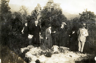 |
| Caley’s Repulse – as it appeared on the day of discovery. Friday September 6th 1912. Group reading from Left to Right: G.R. Nicholls; G.H. Gifford; Mrs A.G. Foster; C.H. Bertie; A.E. Ancher; E. Oldham; Frank Walker photo (SHS 407) |
In
1913, Mr. Oldham had the cairn rebuilt from the scattered stones around the
site, exactly 100 years after its first discovery by Blaxland. It was decided
by the Historical Society that a memorial should be placed near the Cairn and
the Government was approached on the subject. The 1914 war intervened, and no
action was taken.
In
1972 in response to Linden residents’ requests, Blue Mountains City Council
placed a fence around it with a plaque. Whether this was the original cairn
noted by Blaxland, Macquarie and others is open to conjecture. There is no
mention of it by travellers after 1827, Louisa Anne Meredith for example did
not mention it in 1839.
Alan
Searle of Springwood Historical Society, argued that the true site was on the
eastern side of the Bathurst Road close
to Woodford Trig station. This was based on an 1831 map of WH Govett showing
the ‘Pile of Stones’, and an 1832 survey by HC Butler showing ‘Pile of Stones,
Caley’s Repulse’.
Cecil
Atwell has argued that based on Evans’ bearings in his field book, Govett’s map
and Cox’s journal, the original ‘pile of stones’ was about 150 metres south of
the 580m peak to the north of the Woodford Trig. Stn. (598m) and was probably part
of an Aboriginal track way sign post system. It was near an important junction
of four routes and an important meeting place and close to a place where there
was a large cavern, which provided shelter and water - today's King's Cave, originally
called “Evans’ Cave” by Cox. It was on the eastern side of Cox’s road and was displaced
by Bull’s later road improvements
The
missing side of the pile of stones was actually a representation of the cleft
in the cliffs at Blaxland's ‘cleft’, which would be a mile away at Cox's Pass,
(Cox's naming) or Bluff Bridge (Macquarie's naming). From the rock pile you
could go northerly along Dawes' Ridge to the Grose River; southerly to
Wentworth Falls or easterly to Springwood and down to the creek which led to
Bull's Creek and so eventually to the Grose River. Atwell concludes, “I do not
believe any European built this ‘pile of stones’.”
References:
Atwell,
Cecil. Research notes ‘Caley’s Repulse’, Blue Mountains City Library, Local
Studies collection. 2003
Banks,
E.C. Caley’s Repulse and Mount Twiss, historic spots at Linden, Blue Mountains.
Typescript, March 1943.
Walker,
Frank, F.R.A.H.S. Caley's Repulse, an Old-time Cairn. The Blue Mountain Echo,
25 Feb 1921: 8. Retrieved 7 Nov. 2013, from http://nla.gov.au/nla.news-article108239806


No comments:
Post a Comment