AUTHOR NOTE
The Author has lived in the Blue Mountains all his life born
at Katoomba and moved to Springwood in 1949.
In his early years he gained an intimate knowledge of the region as a
bushwalker. He gained experience of topographic survey and photogrammetry while
working for the Forestry Commission and is an experienced cartographer and
surveyor.
In preparing this booklet acknowledgement is made of the
help and guidance given by Jack Maddock, President of the Springwood Historical
Society and the staff of the Local History Centre of Braemar, Springwood.
PREFACE.
The Bi-centenary of
the founding of Australia in 1788 established an awareness of our
heritage. From now on we will celebrate
a succeeding series of such events and I think it is important to highlight
some of the more notable firsts so that, if for no other reason, we can
establish the roots of our Australian civilisation.
We owe some deference to a man who struggled through some of
the most difficult mountain terrain in the country, carrying provisions such as
salt meat and flour, camping gear, and probably firearms too.
Lieutenant William Dawes was able and intelligent, respected
by all who knew him. His story is one of
an ordinary man who did his duty and acted with responsibility. There are few records of Dawes except those
available in the writings of others.
Unfortunately all of Dawes' personal writings were destroyed.
The story of this man and his adventurous journey is commemorated
in this, the bi-centennial year of his attempt to cross the Blue Mountains,
December 14, 1989.
Lindsay Paish.
 |
| Map by Lindsay Paish 1989 showing Dawes' probable route |
INTRODUCTION.
By 1813 the infant colony was expanding to the north in the
vicinity of the Hunter River and to the south-west through the Cowpastures
towards Picton, Camden and over most of the Cumberland Plain. Land grants were easily obtained by free
settlers, the Military and ticket-of-leave men who had completed their
sentences. But the few agricultural
areas within the plain were hardly sufficient to feed the colony and it was
with some desperation that successive Governors had required that some break be
made through the wild country surrounding the County of Cumberland. The trio of
Blaxland, Lawson and Wentworth, noting the information gathered by previous
explorers, determined that the only practical course must be along the ridge
tops (as the success of Caley in 1804 to Mt. Banks indicated) and it was this
deduction that led to their 1813 achievement.
Prior to the successful crossing a number of attempts were
made to surmount the barrier which, as was evident to the earlier settlers, was
very broken and precipitous in the most part, only becoming easy in the areas
of " wianamatta shale" which makes up the comparatively good land around
the Rose Hill - St. Marys district and also a small patch on the Blue Mountains
around Springwood. The broken sandstone
cliffs which surround the Hawkesbury River and the Lower Blue Mountains were
extremely hazardous and dangerous to the men who had not the advantages of our
present day footwear and clothing. It
was over this treacherous country that early mountain explorers had to travel
-vertical cliffs, deep gullies, rough, broken creek beds, rocky outcrops and
barren ridges. The appearance to the
English was aptly described by Surgeon White in a letter to Mr. Skill of The
Strand, London: "... the country, my Lord, in past dispute a wretched one
..."
Governor King sent a party over the region to the north of
the Grose River in November 1805. They
set their course from the junction of the Grose and Hawkesbury Rivers, headed
due west for a distance of forty miles
(64 km) and rose to the summit of the first range and traversed some of the
rich country around Bilpin and Mt. Tomah.
They reached a high prominence and saw at a distance of about 12 miles
(20 km) another tall mountain (probably Mt. Banks). On this first mountain they discovered a
cairn of stones which King believed to be erected by Bass, who had journeyed in
that vicinity some nine years earlier.
King described the mountains as a "stupendous barrier".
Caley reached Mt. Banks on the 22nd of December 1804, twelve days after setting out from the junction of the Grose and Hawkesbury Rivers, travelling W.W.N.W. For the first three miles the country was good grazing land, but the rest of the land traversed was rough and barren. His view from the crest of Mt. Banks, to the westward, was of further mountainous country but no great gorges such as the Grose were in evidence. After his return, his opinion was that the limit of cultivation was the foothills of the mountains.
Most of the country
was so sterile that Caley described it as -"the roughest of the country I
found, beyond description -" and, referring to the lack of wildlife on the
more barren ridges -"one of Caley's men remarked that they must have lost
their way when they saw two crows - "
(In respect of the Linden monument, no record of Caley's
shows of his attempt in this direction, though he does note an effort to cross
by horseback. If he had reached this
point, however, he would have made some record of it, because of the nature of
the terrain and the distance.)
The exploring trip by Ensign Francis Barrallier, to a point
in the vicinity of the Jenolan Caves in November 1802, is far enough out of
this district not to warrant any expansion here, though the reason for his trip
was the crossing of the mountains. Similarly, the trip of John Wilson,
southward through the Cow Pastures does not need expanding upon here.
In 1796 Surgeon George Bass crossed the Hawkesbury and
proceeded westward to the rich area of Bilpin and Mt. Tomah. At the terminus of his journey he erected a
cairn which was later noted by Governor King in his journey of 1805.
An attempt at a crossing was made through the Lower Blue
Mountains by the former quartermaster of the "Sirius", Henry Hacking
in August 1794. He reported that his path crossed eighteen or nineteen ridges
of high rocks. David Collins mentioned
in his "Account",
—they saw but one native in the desolate region, and he fled from their approach, preferring the solitary enjoyment of his rocks and woods, with liberty, to any intercourse with them. These hills appear to extend very far to the northward and the southward. An impossible barrier seems fixed to the westward and little hope was left of extending cultivation beyond the limits of the County of Cumberland.—
The terminal point of Henry Hacking's attempt to negotiate a
passage of the Blue Mountains, was submitted for record to the Department of Lands,
Sydney in November 1903, as being defined by the cairn discovered by Blaxland
and party in 1813.
“It is assumed that the cairn as submitted for record is the
one known as Caley's Repulse - at Linden.”
The original location of the cairn, noted as Kealey's Pile (Blaxland)
may never be accurately determined due to the extensive and varied works
associated with the Highway and the Railway.
It can be said, however, that the original monument was in this
immediate vicinity.
Captain Paterson touched on the north side of the Lower Blue
Mountains when he tried to gain access to the western country by way of the
rivers. He followed the Hawkesbury as
Phillip had done, but took with him boats of shallower draft than the
Governor's and so was able to travel over the rapids that stopped Phillip in
1789. After leaving Richmond Hill:
... this part of the river carried him to the westward and into the chasm seen to divide the high land, with some difficulty and some danger, meeting in the space of ten miles, no less than five waterfalls. Above this part the water was about fifteen yards from side to side ...
It was supposed that he had travelled ten miles further up
the river than before, naming the "Grose River" and a high peak they
had in view in the chasm, the "Harrington Peak". This was in September 1793.
A series of stupendous achievements considering the alien
nature of the country. Achievements which culminated in the 1813 crossing
overland that, to the European mind, was desolate, infertile and of unbelievable
roughness. Land which was first
traversed by an indomitable Lieutenant of Marines - William Dawes.
 |
| Portrait of William Dawes image courtesy Rocks Discovery Museum |
THE MAN.
William Dawes was somewhat of an enigma, a man who left
little of his own work, but who ought to have given so much information about
himself. Many of his personal papers and
letters have been destroyed and most information about the man must be drawn
from the writings of many of his contemporaries. There is no man among our founders who has
provided so little about himself and his views.
What we know about him is through the statements of others.
Dawes was born 1762, the eldest son of Benjamin Dawes, a
clerk of works in the Ordinance Office at Portsmouth, England. In 1779 he was gazetted as a Second
Lieutenant in the Royal Marines and served on the "Resolution". He saw action in Chesapeake Bay, Maryland, in
the War of Independence where he was wounded in 1781.
Upon his return to England he pursued skills of surveying
and engineering and became a competent astronomer, a firm friend of Dr. Maskeylyne,
the Royal Astronomer. Dawes was a
gentleman in the true meaning of the word, he was much respected by his
contemporaries, and was skilled and conscientious in all tasks he undertook. "To give you his character in a few words, he is a most
amiable man, and though young, truly religious, without any appearance of
formal sanctity. He is kind to
everyone. He has a great share of
general knowledge, studious, yet ever cheerful, and the goodness of his
disposition renders him esteemed and respected by all who know him " and
further in reference to his skill as an astronomer Mrs. Elizabeth Macarthur
says " - he is so engaged with the stars that to mortal eyes he is not
always visible."
When the First Fleet was being prepared Lieutenant Dawes
volunteered for service. Due to his
contact with Dr. Maskeylyne and his ability as an astronomer, Dawes was charged
with the task of observing a comet which was supposed to reappear in the
Southern Skies in 1788. To this end he
was instructed to set up an observatory, and a great deal of technical and
valuable equipment was made available by the Board of Longitude. Dawes was such an able person that it was his
responsibility to maintain these delicate astronomical and meteorological
instruments. The "Timekeeper", one of the most important pieces,
particularly for navigation, was under Dawes' management and he, Captain Hunter
or Governor Phillip were always to be present for the 'winding' at noon each
day.
McAfee stated that - "For work in Australia it was
indeed fortunate that such a conscientious and thorough scientist as Dawes was
given these tasks."
On the voyage out Dawes continued to follow his readings and
studies and at every opportunity made contact with local astronomers at each
landfall. In November 1787 Governor
Phillip, Lt. King and Lt. Dawes transferred from the "Sirius" to the
"Supply" as the latter was a faster ship and Capt. Phillip wished to
reach Botany Bay first.
Upon reaching Botany Bay Lieutenant Dawes was among the
first to explore the interior and found the country unattractive and unsuitable
for settlement. The results of these
investigations prompted Phillip to move to Port Jackson.
Dawes was not drafted ashore until July 1788 and in the
intervening time worked incessantly to complete the construction of an
observatory to house the precious astronomical and meteorological instruments
entrusted to him by the Board of Longitude.
The building was constructed on the western point of Sydney Cove and
consisted of a small lean-to shed attached to an octagonal building designed to
allow observation of the stars through the roof.
This building became the cultural and intellectual centre of
the infant colony and the area around it became known as Dawes Point. However,
at Dawes' request, Capt. Hunter - "was pleased to honour this Point by
calling it Point Maskeylyne" after the Astronomer Royal who had delegated
Dawes to make observations. However, the
popular name of "Dawes Point" has remained to this day.
The early struggles of the new colony demanded much time and
energy from the resident astronomer and unofficial meteorologist. Apart from his duties as an officer to the
Royal Marines as well as his observations of Astronomy and detailed recording
of meteorological data, Dawes was involved in laying out the first streets and
allotments in Sydney and Parramatta. In
addition, Dawes participated in several expeditions accompanied by Watkin
Tench.
Dawes' participation
in these expeditions was of great importance, Captain Tench stated in his
complete account of the settlement of Port Jackson:
Our method on these expeditions
was to steer by compass, noting the different courses as we proceeded; and counting the number of paces, of which
two thousand two hundred on good ground were allowed to be a mile. At night, when we halted, all these courses
were separately cast up, and worked by a traverse table in the manner of a
ship's reckoning is kept; so that by
observing this precaution we always knew exactly where we were, and how far
from home; an unspeakable advantage in a
new colony, where one hill and one tree, is so like another that fatal
wonderings would ensue without it. This arduous task was always allotted to Mr.
Dawes who, from habit and superior skill, performed it almost without a stop or
interruption of conversation; to any
other man, on such terms, it would have been impracticable.
This man, this scientist and recorder, was responsible for
the early exploration of the Colony of N.S.W.
A man of great general knowledge and skilled application of his
abilities, was liked by all who knew him and, as would later be revealed, a man
of great compassion. William Dawes was
the first recorded white man to penetrate the Blue Mountains.
 |
| Dawes' map drawn 1791, image: nla.obj-230635598 |
EXPLORATION AND DISCOVERY.
In the early days of settlement the infant colony depended
for its subsistence almost entirely on that which was brought in; no reliance could be placed on early
agricultural efforts, animals could not be considered suitable to supplement
the diet for upwards of five thousand souls.
Although cultivation was begun under the direction of Governor Phillip
almost immediately after the first settlers landed, it was soon found that the
soil was so inferior that the crops were not nearly as good as was
expected. It was with these troubles on
his mind that Phillip started out on his trips of discovery. On his first journey to the north, past what
is now the Narrabeen Lakes, he had a full view of what he called "The Blue
Mountains". He was determined to
reach the summit of those mountains with the object of extending the area of
cultivation. In the meantime, the area
around Rose Hill was discovered and it was from this area that further
exploration was carried out.
Governor Phillip, accompanied by Admiral John Hunter,
travelled to the north west discovering the Hawkesbury River which they crossed
and, on the north side on the 5th July 1789, reached an high hill which he
called "Richmond Hill". It is
recorded in Hunter's Journal of that date - "this range of mountains we
supposed to be those which are seen from Port Jackson and called "The Blue
Mountains" - in that range of highland there is a remarkable gully or
chasm, from which we appeared to be distant about five miles ! It was at this point that Phillip named the
high basalt hills (Mt. Hay, Mt. Irvine etc) to the north of this chasm, the
"Carmarthen Mountains" and those to the south the "Landsdowne
Hills" (the Lower Blue Mountains).
There is little doubt
that these mountains held a strong attraction for Phillip as is borne out by
his repeated attempts and his instructions to others to reach and cross them.
Tench remarks:
. . . at a distance of sixty miles inland a
prodigious chain of lofty mountains runs in a nearly north south direction,
farther than the eye can trace them.
Should nothing intervene to prevent it, the Governor intends shortly to
explore their summits and I think that there can be little doubt that his curiosity
will not go unrewarded.
By this time conditions in the colony were nearly chaotic;
discipline in the Marine Corps was falling off and control of the convicts was
almost non-existent. Many of the
convicts and a number of officers and men were taking up land grants and
establishing farms on the more arable lands around the settlement, but their
extensive attempts at cultivation were not succeeding because of the extreme
climatic conditions. More convicts were expected each day and the meagre
supplies were not considered sufficient to cope even with the relief by the
establishment of Norfolk Island.
The Governor aided the taking up of land by making free
grants of land to settlers and in lieu of fees or quit rent, these settlers
undertook to take charge of and feed a number of convicts, thus relieving the
strain on the Government Stores. It was
in this early period of land-grabbing development, that David Collins stated
"—-a knowledge of the interior parts of this extensive country was
anxiously desired by everyone — "
In December 1789, Governor Phillip charged Dawes with the
task of reaching the western mountains from a freshwater stream that Tench had
found earlier and believed to be a tributary of the Hawkesbury, Collins'
statement continued "—with a small party taking with them as many
provisions as they could conveniently carry, set off in an attempt to reach the
western mountains. This excursion he
returned on the ninth day without accomplishing his design."
Tench records that the party was made up of Lieutenant Dawes
of the Marines accompanied by Lieutenant Johnston and Mr. Lowes.
 |
| Emu Ford on the Nepean River 1958, image Blue Mountains Library |
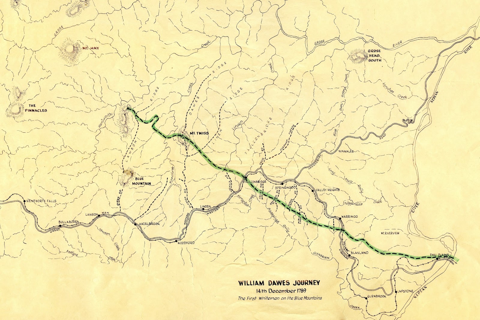
Dawes' small party left the ford at Emu on the Nepean and
began his journey to the mountains. From
the available information on this trip, it is obvious that the objective of the
trip was Round Hill (Mt. Hay) either by Dawes' own design or direction of the
Governor. It could easily be conceived
that this hill was the crest of the range and that an extensive view could be
gained from the summit which would no doubt aid in the formulation of a more
concrete plan to result in an ultimate crossing. Dawes headed directly for that hill.
On the first day of the journey, as the foothills obscured a
view of Round Hill, the party headed west until reaching the crest of the first
ridge (about the location of Mt. Riverview). From here there is a good view of
Round Hill and Dawes altered course slightly to head directly to it.
With Round Hill as a
landmark, Dawes headed directly for it and crossed the main ridge, dividing the
waters of the Grose and Nepean, at a point somewhat east of Warrimoo
Station. Continuing, at least six major
creeks that drain southward from Valley Heights were crossed - an arduous task
requiring considerable effort in climbing into and out of them. In fact, the whole of the journey involved
ascending and descending the gullies of the Lower Mountains.
Dawes crossed the ridge south of Springwood near the last
house in Farm Road, next to the Bee Farm Road ridge which was crossed near the
Rifle Range. Down into Sassafras Gully
onwards to the main ridge about Faulconbridge Station. After crossing the main ridge the second
time, Dawes’ party made their way down a succession of deep gullies, including
Linden Creek and the Woodford Creek gullies, which are about 700 feet deep (215
metres). They crossed Woodford Creek
about two and a half miles (4 km) below the Linden Dam (or Woodford Tank).
The next major gully after Woodford Creek presents a long
unscaleable cliff on its western flank.
This caused the expedition to take a long, looping deviation northward
around the head of the ridge. On
returning to their line of march a saddle was encountered that led to a bold
ridge 2200 feet (670 metres) above sea level.
This ridge was the terminus of Dawes' journey and he named it Mount
Twiss in honour of an officer in the Royal Engineers. This point appears to be
a hill on the ridge north of what is now known as "Blue Mountain".
From the summit of this ridge which was reached on 14th
December, an extensive view of the Carmarthen Mountains is gained, whilst at
its foot is Wentworth Creek, some 900 feet (275 metres) deep and the roughest
gully in the mountains. Being confronted
with this formidable barrier and considering the increased wildness of the
country already traversed Dawes was forced to turn back.
To sum up the journey the statement of David Collins refers
to Dawes:
- - meeting with nothing after
quitting the river, but ravines that were nearly inaccessible. He had, notwithstanding the danger and
difficulty of getting through such country, reached within eleven miles of the
mountains by computation.
In this journey, Lieutenant
Dawes' line of march, unfortunately and unpleasantly for him, happened to be,
nearly from his setting out, across a line of high and steep rock precipices,
which required such caution in descending as well as labour in ascending.
It is interesting to compare the line of travel covered by
Blaxland and the route Dawes took. Dawes
covered 15 miles (24 km) with an average grade of 1 in 2 descending and
ascending 800 feet (244 metres) into and out of the mountain gullies, while
Blaxland travelled over 22 miles (35 km) to reach a point as far west, along
the crest of a ridge that had an average grade of 1 in 15, with the only steep
parts being those of Emu Hill and the Bluff Ridge at Linden.
It is highly
improbable that there is any cairn or monument to mark the terminus of Dawes'
journey and the many investigations that have been undertaken to establish the
location of Mount Twiss have all been inconclusive due to the lack of an
accurate description. However, logic and learned interpretation must locate
this Mount Twiss on the Blue Mountain ridge.
Dawes continued to be included in the early reconnaissance
of the settlement, because of his surveying skills, and in August 1790
accompanied by Captain Tench and a man named Morgan travelled southward towards
Pyramid Hill and named a river discovered on this trip -the Morgan.
Again in the winter of 1791, with Tench, Dawes verified the
unity of the Nepean (located by Tench in June 1789) and the Hawkesbury,
discovered by Governor Phillip and Captain Hunter in July 1789.
EPILOGUE.
In October 1788 Dawes had applied for three years’ service
in the colony and until 1791 he had seriously considered settling in New South
Wales. He was totally committed to his
astronomical pursuits as well as recording the weather. He also had official responsibilities in his
capacity as an officer of the Royal Marines.
Late in 1790 there was an altercation between the local
Aborigines and one of Phillip's wardens who was speared to death. Phillip was enraged and ordered a punitive
expedition against the tribe, instructing Captain Tench and Lt. Dawes to take
and execute ten natives in reprisal. There was some suspicion that the Warden
had fomented the trouble with the natives and perhaps had deserved the
spearing. Lt. Dawes' doubts appeared to
be deeper and he refused, at first, to participate in the punitive expedition
at all. However, at the behest of Tench
and Collins he eventually relented and obeyed the Governor's order.
On returning from the expedition Dawes informed the Governor
that he was sorry he had been persuaded to comply with the order and very
clearly showed that he would not obey a similar order in the future. Lieutenant Dawes' expressions were such that
would have subjected him to Court Martial should the Governor have been
inclined. Dawes' past service and his
character were in his favour and the Governor did not proceed with any
disciplinary action. However, it meant
that Dawes was no longer welcome in the colony and he returned to England on
the "Gorgon" in December 1791
Dawes' movements after he returned to England are not very
well documented but it is known that his compassion led him to be involved in
the anti-slavery campaign.
Dawes married in 1799.
His son, William Rutter Dawes, became a well-known astronomer. After his first wife died, Dawes married
again and a daughter of this second marriage, was a Mrs. Jones, a well-known
slave abolitionist.
Dawes was involved in
the Sierra Leone Company and served three times as Governor. The company was an anti-slavery organisation,
an appropriate choice for this man of compassion. Dawes died in 1836 at
Antigua. There was, however, no death certificate available for a Lieutenant
William Dawes; his death, like most of
his life, remains undocumented.
Zachery McCauley, Governor of the Sierra Leone Company in
turn with Dawes wrote in 1796 - "Dawes is one of the excellent of the
Earth"
FOOTNOTES.
Footnote 1.
It would appear that the commonly accepted first crossing of
the Blue Mountains by Blaxland, Wentworth and Lawson could have been a matter
of political expediency. The accounts of
Governor Hunter refer to the expedition of John Wilson who travelled a distance
of about 116 miles (186 km) in a south-westerly direction to a river flowing
from the S.E. to the N.W. Planning out this journey gives an approximation to
the headwaters of the Lachlan River. The trip was undertaken in the first
months of 1798.
John Wilson was an ex-convict, a vagabond and spent some
time living with the natives. He was expert in bush craft and bush travel, had
great powers of endurance and proved himself adept in sustaining the lives of
his party unencumbered by heavy burdens.
In his transcription of his journal he mentioned a
"cliff of salt" which was later disproved by Henry Hacking.
This mischievous untruth, without doubt, did much to destroy
credence of the land travel undergone. The evidence justifies the conclusion
that the passage of the Blue Mountains in 1798 becomes a matter of historical
fact.
One wonders if John Wilson had been a respected landowner
and a member of the colonial aristocracy like Blaxland, instead of an
ex-convict gone native, would his discoveries have been heralded as the
breakthrough out of the encircling mountains.
However, as proclaimed in the history books - Blaxland,
Wentworth and Lawson were the first to cross the Blue Mountains in 1813.
Footnote 2.
The main record of Dawes' mountain journey is the map of the
area contained in Watkin Tench's "Complete Account of Settlement".
The excellent drawing of the map with the accurate depiction of the major
features of the country that it shows, the outline of Sydney Harbour and the
relative positions of the hills and rivers, leave no doubt as to the
authenticity of the diagram of his mountain trip. So we may rightly assume that this area, as
shown, was as he saw it.
Numerous attempts have been made in search of Mt. Twiss,
among the most notable was a comprehensive, detailed and exhaustive analysis of
the evidence undertaken by F.A. Craft and R. Else-Mitchell in 1941, in which
they say –
...we are therefore able to conclude in the light of the researches and investigations which we have carried out in the field, that we have located and identified Mt. Twiss.
In assessing the route, Dawes followed the only information
available which was this map of the area, printed in 1791, on which a diagram
of the traverse is shown in remarkable detail although small in scale. The only other snippet is the statement that
he reached a point fifteen miles from the river. Putting these two factors together and
relating them to the modern ordinance map a basic approximation of the route
can be determined. As previously mentioned, Dawes was meticulous in his
recording of journeys and there is no reason to believe that this diagram would
be in error. Clarke and Mitchell, in their analysis of the journey, finally
assumed that in the actual distance travelled and, on this assumption,
determined Mt. Twiss to be located on Linden Ridge.
However, utilising the available information and accepting
it as correct, the writer has set the line of traverse in direction and
distance. The critical determination of
the correctness of this line is then based on a comparison of each different
feature from the ordinance map and from Dawes' 1791 map. The shape of each feature crossed, as defined
by Dawes, is in the form of ridges and the line of the ridge towards its
head. The comparison shows that the
number of ridges crossed related to the actual features is in order.
Without creating any further controversy and, indeed, the
simple fact that Dawes did record the first traverse of a white man into the
mountains is achievement enough and his precise terminal point has been and
will be a matter of conjecture and is really of no consequence.
The mountain located by Craft and Mitchell lies about 2
miles due north of the Woodford Dam Reservoir on a spur from the Linden
Ridge. This location has been officially
adopted by the Geographical Names Board.
BIBLOGRAPHY
·
Complete account of Settlement at Port Jackson
in New South Wales -1793 - Watkin Tench.
·
N.S.W. - Historical Records Vol 1 pt. 2
·
Historical Journal of Admiral John Hunter Page 151
·
Historical Records of Australia Series 13 Vol 1
·
History of New South Wales - G.B. Barton Vol 1
·
Account of the English Colony of N.S.W. - David
Collins
·
Guide Book to the excursions to the Blue
Mountains and Lithgow3 19233 Pacific Science Congress - Exploration by H.R.
Cambage, F.L.S.
·
First Crossing of the Blue Mountains (Newspaper
Clipping) F. Walker3 Royal Australian Historical Societies Journal Vol 25 page.
475-519
·
F. Arnold Wood "Lt. William Howes and
Captain Catkin Tench" Journal, Royal Australian Historical Society - 1924
p.p. 1-24
·
Letter of Daniel Southwell April 1790
·
Historical Records of New South Wales 1892 -
1901 Vol 1 pt. 2
·
S.M. Onslow (ed) Some early records of the
Macarthurs of Camden -Angus & Robertson, Sydney 1914
·
Jones - Historical Records of New South Wales
Vol 2 pp.19 Wood - Historical Records of New South Wales Vol 2 pp.12
·
Letter of 25 November 1926 to Mitchell Librarian
re Lieutenant W. Dawes from Colonial Secretary of Leeward Islands (West Indies)
Mitchell Library Sydney M.S.S.
·
In Search of Dawes' Mount Twiss - Frank A. Craft
and R. Else Mitchell -Journal of the Royal Australian Historical Society 1941
·
Dawes' Meteorological Journal - Robert J. McAfee
·
Department of Science and Technology -
Australian Government Publishing Service – 1981
Originally Published by: Braemar 530A Committee, Local History Centre, Macquarie Road, SPRINGWOOD 2777
Copyright (c) 1989: Lindsay Paish
LINKS
Dawes' portrait
Dawes' Map
Dawes, William (1762–1836) ADB
"MOUNT TWISS CONTROVERSY" The Blue Mountain Echo (NSW : 1909 - 1928)22 October 1926: 1. Web. 15 Aug 2017
LINKS
Dawes' portrait
Dawes' Map
Dawes, William (1762–1836) ADB
"MOUNT TWISS CONTROVERSY" The Blue Mountain Echo (NSW : 1909 - 1928)22 October 1926: 1. Web. 15 Aug 2017
Edited by John Merriman, Local Studies Librarian, 2017


